Daily news, dev blogs, and stories from Game Developer straight to your inbox
Sponsored By
Featured Blog | This community-written post highlights the best of what the game industry has to offer. Read more like it on the Game Developer Blogs.
What does it take to design Multiplayer maps for Assassin's Creed franchise ? Using Saba Island map as an example, I'll try to give an insight at the very deep process of mixing History and Gameplay in a unique Multiplayer experience.
16 Min Read

Note : this post is a more detailed version of a post I initially wrote for AC fans and that will be published on the AC multiplayer website.
Hi, my name is Chadi EL-ZIBAOUI I’m the Lead Level Designer for AC multiplayer maps, I’ve been working on ACMP since ACB, my first map as a Level Designer was Mont Saint Michel.
When I first took the LD test 4 years ago I didn’t know anything about the project’s details, the only information I had was that a multiplayer for AC franchise was under development in Annecy studio. Contrary to an FPS multiplayer mode, I had no existing game references on which I could rely on, except AC solo itself. At that time, I had played AC1 a few hours, and if I remember correctly I’ve completed Damascus, and that was it. I thus grabbed a copy of AC2, and I played intensely, completing almost 100% of it. Not only did I play it but I paid particular attention to the “behind the scenes” aspects and tried to figure out what were the recipes behind the assets production, climbing design, LD, and metrics amongst others. Once I’d drawn my conclusions, I jumped into the test, and gave it my best, which allowed me to join the team in May 2010 during a very dynamic period of the production - just before the game was revealed to the press at E3.
MAP DESIGN PHILOSOPHY AND PROCESS
This said, let me introduce a few concepts that are part of our general work philosophy and that might help have a better understanding when I'll be talking about Saba Island case.
A dedicated map team organization
The map's team organization was one of the first thing I had to get familiar with. The team has been shaped from the beginning to be tailored with the franchise and project needs, which in our case means designing maps that fairly merges gameplay requirements and strong historical background with urban planning and architectural foundations.
For example, we have several map ‘strike teams’ made up of 2 level designers (responsible for the gameplay aspect of the map) and 4 to 5 level artists (responsible for the graphical content of the map) working closely together from the map conception phase to the final release of the fully polished map. Not only do they exchange a lot of ideas and nourish themselves with their teammate’s expertise, but they have different level of knowledge and practice of their counterpart’s jobs.
For instance, Level Artists are familiar with Level Design ingredients and constraints, and inversely LDs are familiar with 3D software packages.
Map Genesis
Every time we start an AC multiplayer game, our main objective in the map team is to provide our players with the greatest variety we can deliver on schedule and with the higest quality. Evidently, when talking about variety I mean level design and visual identity.
The visual variety will stem from the context and period itself, whereas the level design variety will be influenced by analyzing data tracked on previous AC projects (obviously we look at the most played map and try to identify their most popular specific ingredients), and making sure it addresses the two main gameplay styles you can experience in ACMP maps, Acrobatic play versus Stealth play.
As an example, a map in which navigation is constrained to the ground-level for the majorioty (Castel Gandolfo in ACB, Souk in ACR, Brewery in AC3, Pirate Headquarter in ACBF…) is labelled “stealth” and players are encouraged to stay in low-profile and play with the crowd to outwit their target, whereas a map that allows navigation on different levels (whether it be grounds or roofs) is labelled “acrobatic” as it will offer more aerial navigation opportunities (Mont Saint Michel in ACB, Galata in ACR, Animus Core in AC3, Saba Island in ACBF).
With these constraints in mind, the team can start gathering map conception proposals which we will then study and select the ones we think best suited with the game. Once these concepts are validated, the team can start getting further into the details, developing the visual identity of each area of the map, providing a first level design which will generally consists of a 2D Ariel view and a 3D prototype so we can experience and evaluate rough volumes and navigation.
Two strong pillars, Navigation and Orientation
Obviously, navigation and orientation are two things we will focus on during the whole development of the map.
Regarding navigation, maps have to support our core gameplay by providing a navigation-friendly environment to the players. In the multiplayer mode, we want players to be able to focus on their main objective (that is, the other players) rather than struggling with their environment. Thus maps should not be a difficulty ingredient but rather a tool, which players should try to make the most out of, and use at their benefit. It would be very frustrating for players to get killed or to miss their target because of design flaw in the maps (i.e. getting stuck while climbing), Therefore we put a lot of effort on polishing and debugging the navigation elements of the map.
The second big focus is orientation. Landmarks are very important to allow players to get their bearings or to let their teammates know where they are, we always pay special attention to this. There are different types of landmarks:
Unique buildings/monuments (the Pantheon in Roma, the Abbey in Mont Saint Michel, the wrecked ships in Northwest Passage…)
Typical areas (a market, a garden, a pond…)
Natural elements, such as solar orientation, and resulting shading
This is very close to what you would do in real life, you usually rely on places which are easy to identify to give directions to someone or to find your way in an unknown place.
History as food for thought
AC is a very motivating and enriching franchise for it forces us to be immersed into historical aspects every time we start a new AC project. As Level Designer or Level Artist, we need to fully immerse ourselves into history, urban planning, architecture, lifestyle and almost anything related to the period and locations in which the game is taking place. In the maps team, we pay particular attention to the research phase (which can sometimes involve taking courses with lecturers from Museum’s) to provide players with realistic and believable environment, History being one of the brand’s pillar. Besides providing historical accuracy, this will also give birth to level design ideas.
Sometimes players will notice the details we spent time polishing, and sometimes they won’t directly perceive it, but this consistent whole will provide them with a smooth game experience.
SABA ISLAND CASE
I will now explain the life cycle of a map using Saba Island from ACBF as an example. There is a lot to say, thus I tried to simplify the content so you can have a general idea about how maps are designed for ACMP rather than going into too many details.
Early Concept
Saba Island’s history started during DLC maps research for ACIII, but at that time we agreed that it wouldn’t fit easily with the American Revolution context. The location which inspired this map was Mesa Verde in Colorado. These are the kind of references that shaped our first visual and gameplay intentions for the map.
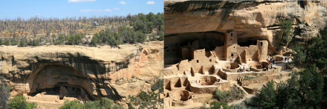
If you had the chance to try our multiplayer mode I’m sure you can point out why this place is the mother of Saba Island. Actually this map was the Map Content Director’s fantasy, he literally fell in love with that place and when we all started looking at it we were seduced by its potential too.
We started writing a kind of pre-concept for the map in which the main ideas are resumed as:
A village built under the rocks with houses dug into it.
A terrain with differences in height.
An organic and wild area in the center of the map
Additionally, the idea of a light well in the center of the map was put on the table very early.
Acrobatic gameplay in the village area, with a lot of ground-to-roof and roof-to-ground opportunities, (the reference here was Mont Saint Michel which is still the map with the greatest downslope).
A more flat area in the middle of the map to encourage a more stealth/ground focused gameplay.
We gathered some visual references, historical and geographical information, and that was it. The idea was put aside, but not for long.
When we started ACIV Black Flag we got really excited by the Pirate theme and Mesa Verde’s idea naturally came back to surface.
It became obvious to us that we would build a secret pirate lair (which was actually the name of the map during its production).
Different maps, different realities
That said, when we start a map we rely on 4 different kinds of realities to adapt it more or less so it fits with our gameplay:
Reality itself. When we find an appealing location which is consistent with the game context and that already provides the roots of an interesting layout, we will start gathering as much information and blueprints as we can, we’ll then make the adjustment needed to support the gameplay (as an example, we can mention Saint Pierre in AC3, or San Marco in ACB)
AC Solo Reality. When we want to represent a location the solo campaign already showcases, we need to start from the reality they already adapted. It’s not a simple crop in which we can integrate our gamemode, there’s a quiet an important level of adaptation work that is conducted to fit with our gameplay which is different from theirs (Roma in ACB, Galata in ACR, Boston Harbour in AC3). We usually provide one or two maps of that category to have a better connection with the solo part of the game.
Real places, fake locations. In this case, we have a strong theme we find very interesting but we didn’t find an existing place friendly enough to represent it faithfully. Let’s take New York Brewery example. This place didn’t exist as we represented it in the game but we gathered enough documentation about breweries at that time so it looks credible and inspired from reality.
Fantasy. These are locations which we know don’t exist but they exist in pop culture or collective imagination. This was the case of Animus Core in AC3 (which was linked to the Animus fantasy and closely linked to the brand’s DNA), and Saba Island in ACBF which is the map we are talking about.
Saba Island belongs to this last category, as a matter of fact we couldn’t start with real urban plans to build the foundations of our layout. Starting with a real urban planning does indeed have some advantages.
Firstly, urban planning is the result of a lot of parameters that experts dealt with to organize streets, places, housing, etc. over centuries. This means that things are where they are for a reason and we need to understand why because we don't want to reinvent urban planning rules.
Secondly, everyone has developed their own perception of the city and its codes because off all these rules, this is something you experience in everyday life. As a brief example, you can make the difference between a street or an avenue because of its width and you can guess if you’re making your way in a rich or poor neighborhood just because of the materials and the street furniture around you. There are a lot of things in a city that will help you understand your environment and this is what we focus on when we design a map which is not directly inspired by an existing location; we rely on these codes to shape our layout.
From Concept to Prototypes
This leads me to the next step, based on the visual and gameplay intentions from the concept we will make a first detailed map design of it. The work is split in two parts but in the end they are closely linked to each other: defining visual identity of the various areas of the map on one hand, and prototyping a first 2D layout on the other hand.
The team will then provide a set of documents with all the information needed to start building the map.
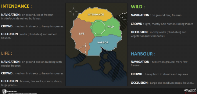
The identities of each area will give information about the different moods and also give information about gameplay intention. 4 areas were identified by the team for Saba Island:
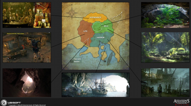
Area Identities early version
Gameplay Intentions early version
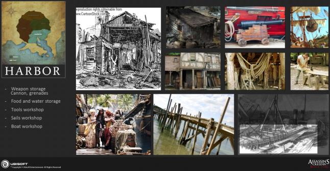
The intendance area was supposed to be the logistics and supplies area where they could store their treasures also; the wild area was the only part of the map where there wouldn’t be any construction; the harbor would host everything related to boats with repairing workshop; the life area would be the place where the pirates can have a drink and some food.
Each one of these areas and its characteristics are detailed and illustrated in the Design Document.
Alongside this, more information about the global topology is gathered to help us figure out further, what will the map look and feel like.
Thus, the Level Designers draw first 2D plans where they identified the main streets and places, the different ground levels, the crowd network, the chase breakers, and the hiding places. Once all this information has been validated, we start building the first 3D prototype in our editor with placeholder assets (simple shapes or assets from previous games). This is what helps us to quickly have first impressions about the map and define the next steps.
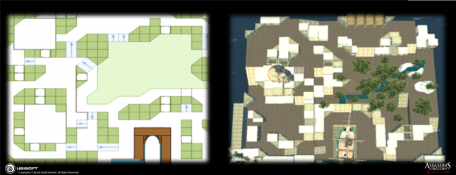
2D top view and resulting 3D prototype
You can notice that the above top view is quite different from the map you can play in the game but you already find the main ingredients. This is the result of a lot of questioning and iteration every map goes through. These are some of the main questions we raised about Saba Island and for each one, the team built prototypes to test if it was good directions to follow.
First, we wanted to weigh up the pros and cons about having a boat inside the playable area, different prototypes with different size of boats and orientation were made. The good point was that it provided a great mood to the whole map; a secret pirate lair wouldn’t be without a boat, right? Also, as a landmark it was very useful for player’s to be able orientate them. The challenging part was concerning the shape impeding easy and quick stealth navigation between the two parts of the harbor. As for every decision of that kind, there are different people involved because we need to take into consideration artistic, level design and technical constraints to choose the right solution. We decided to integrate the boat and pay extra attention to how it’s linked to the rest of the map through stairs deserving the upper deck, and free run to connect it with the Jungle part to the north of the boat.
Regarding the Jungle, the challenge was coming from the use of organic shapes such as trees and rocks. We had a similar experience with Northwest Passage, we knew it was challenging and that it would need a lot of effort to provide a clean and polished navigation. Beneficially, it would create a unique playground with a more stealth oriented gameplay. However, it should not disadvantage players who like to play it acrobatically, thus, we integrated a few free runs above the area. As for the boat, it would also be a very recognizable area which was always a strong motivation behind our choices. Believe me, a lot of shapes prototyping and cleanup has been done on that area, but eventually, the team came up with adapted solution and everyone was satisfied by the final result.
Another topic the team had to focus on was the building’s design in the city/built-up area. We wanted to assess the benefits of having houses dug in the rocks and linked to the natural ceiling of the cave, as in Mesa Verde’s references. Again we started prototyping different ideas, such as using the roofs of lower building as a ground for NPCs, narrow alleys dug into the rock and houses built from ground to the ceiling of the cave. This particular point can be delicate. If a house is built that way, when you start climbing its frontage, you don’t know that you won’t be able to reach its roof since it doesn’t have one, so we can’t let the player land on such a surprise. What we did is create an intermediary roof before the end of the building and we tweaked the climbing so you always reach it wherever you start climbing this building. On top of that we identified this particular building as the Chief’s house that would be the landmark for that area.
The team could now go further and focus on these strong directions we built with them, the work of prototyping, play testing and analysis will start a new loop, at the end of it we will define the next steps again.
A key ingredient to the quality of the modifications we do in the maps is the player himself. Very early, when we have a first playable version of the map with most of the ingredients and game modes integrated, we start showing the map to external play testers, we ask them to play several hours and gather their impressions in addition to data recorded by our servers during their games (player position, kill locations, hiding places usage…). We make maps for players and when we can get the information at its source, it’s a godsend and very precious to us.
Evidently, we need to stop that process at one point, because otherwise, it’s a never-ending-story and you can always improve a map. However, it can’t be stopped in one go, so the more we move forward in time, the smaller the modifications get. When we are satisfied with the map gameplay feel, we can focus on game modes balancing and tweaking, crowd adjustments, polishing navigation and assets, I will detail that part in another post.
Read more about:
Featured BlogsAbout the Author(s)
You May Also Like